Calculating
Coastal Change Rates
For
Northwest Oregon
And
Southwest Washington

Richard
C. Daniels (rdan461@ecy.wa.gov)
Coastal Monitoring &
Analysis Program
Department of Ecology
P.O. Box 47600
Olympia, WA 98504-7600
Preprint from Proceedings of GeoTools ’01, January
8-11, 2001,
Charleston, South Carolina
CALCULATING COASTAL CHANGE RATES FOR NORTHWEST OREGON AND SOUTHWEST WASHINGTON
Richard C. Daniels (rdan461@ecy.wa.gov)
Coastal
Monitoring & Analysis Program, Department of Ecology
P.O. Box 47600
Olympia, WA 98504-7600
Pacific Northwest, Washington, Oregon, Erosion, Change Rates
INTRODUCTION
A
chronological set of historical shorelines have been compiled for the Columbia
River Littoral Cell (CRLC) by the Washington Department of Ecology (Ecology) in
support of the Southwest Washington Coastal Erosion Study. The shorelines were
digitized or calculated for the CRLC from historical maps and charts, aerial
photos, orthophotography, and Light Detection and Ranging data (LIDAR). These
data have been used to calculate shoreline change rates for the entire littoral
cell. This paper describes the methods used to calculate these change rates.
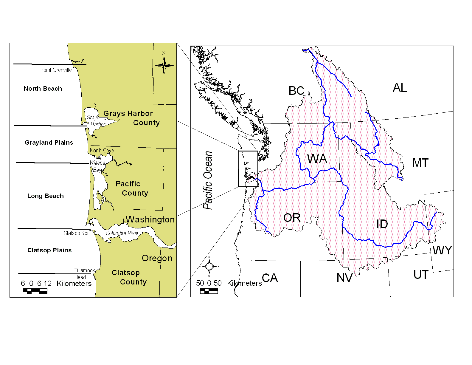
Figure 1. Relative size of the Columbia River basin (right) in relation to the Columbia River Littoral Cell (left). Note that the Columbia River Littoral Cell is divided into four sub-cells.
The Southwest Washington Coastal Erosion Study is a five-year integrated research project funded and coordinated by Ecology and the U.S. Geological Survey (USGS) Coastal and Marine Geology Program to study coastal processes within the CRLC (Gelfenbaum and Kaminsky 2000). The CRLC extends 32-km south from the mouth of the Columbia River to Tillamook Head, Oregon and northward 132-km to Point Grenville, Washington (Figure 1).
METHODS
In this study a vector approach for calculating erosion and accretion rates from historical shorelines was developed. This method has been successfully applied to shorelines derived from National Ocean Service Topographic Sheets (T-sheets), orthorectified air photography, LIDAR, and GPS ground survey data. Results from this analysis indicate that many of the beaches within the CRLC have transitioned from accretion to no-change or erosion in the last two decades.
The shoreline change program described here was written in Arc Macro Language (AML) for use with ESRI’s Arc/Info software. This program was modified from one described in the proceedings of the 1998 ESRI International User Conference (Daniels and Huxford 1998). The 1998 version of this program calculated the change rates using the GRID module of Arc/Info. This raster processing method was optimized for the calculation of change rates between two shorelines, where each shoreline represented a single month and year.
The limitation imposed by the raster method was that it was impractical to retain the mapping date of each individual shoreline segment during the vector to raster conversion process. Unfortunately, in a study area as large as the CRLC this limitation made it very time consuming to calculate change rates for the entire region. For example, when calculating the shoreline change rates between the 1950’s to 1970’s we ran into the following situations.
(1) The 1950 era shoreline was composed of T-sheets from 1948, 1950, 1952, 1955, and 1957.
(2) The 1970 era shoreline was composed from air photography flown in 1973 and 1974.
To obtain a composite coverage containing the1950era to 1970era change rates the raster-based program must be run a minimum of seven times. To overcome this problem a vector version of the program was developed in 1999. This new version is able to carry the mapping date (as a decimal year) of each individual shoreline throughout the entire analysis. Thus, composite shorelines may now be used as input into the change rate program.
THE AML PROGRAM
This AML is designed to automate the calculation of shoreline change rates between an “old” shoreline and a “new” shoreline. Each shoreline contains a year and month attribute that indicates the time that the shoreline was mapped (on the ground) or photographed. The “main” body of this AML is shown in Table 1, with additional notes added to the right to explain the actions of the given line. Note that “~” is the line continuation character, that AML variable names are of the form %var%, and that a variable may contain either character (e.g., a filename) or numeric values.
Table 1. Main body of the AML program used to calculate shoreline
change rates for the Southwest Washington Coastal Erosion Study.
Command
or Procedure Call Description
&menu change_pt.menu Open a menu to obtain
input/output filenames
NEW_SHORE=new shoreline cover
OLD_SHORE=old shoreline cover
OUT_SHORE=change rate cover
&call setup_temp_files Delete/create temporary files
densifyarc NEW_SHORE temp_pt ~ Add nodes along each arc at
%.distance% arc a given distance (e.g. 100 m)
arcpoint temp_pt %.OUT_SHORE% ~ Convert line coverage temp_pt
line lyear %.distance% to point coverage OUT_SHORE
/* Maximum distance is 3200 m or 2 miles
near %.OUT_SHORE% OLD_SHORE line ~ Calculated distance from each
3200 # nolocation point in OUT_SHORE to the
nearest line in OLD_SHORE
additem %.OUT_SHORE%.pat ~ Add decimal year item to
%.OUT_SHORE%.pat year_old 8 8 f 2 OUT_SHORE
additem %.OUT_SHORE%.pat ~ Add rate item to OUT_SHORE
%.OUT_SHORE%.pat rate 8 8 f 2
tables Start database interface
select %.OUT_SHORE%.pat Select coverage OUT_SHORE
relate restore OLD_SHORE_r1 Restore relate environment
calc year_old = OLD_SHORE//lyear Copy lyear* from coverage
OLD_SHORE to coverage
OUT_SHORE
calc rate = distance/(lyear - year_old) Calculate change rate based
on a distance divided by time
formula
quit Exit tables
&call mask_data Call procedure to create a
polygon coverage based on
OLD_SHORE (the mask coverage
contains variable CODE, where CODE= -1 for land and 1 for ocean)
rename %.OUT_SHORE% temp_shore Rename coverage OUT_SHORE
identity temp_shore mask_pt ~ Copy variable CODE from the
%.OUT_SHORE% point # join mask cover to coverage
OUT_SHORE
tables Start database interface
select %.OUT_SHORE%.pat Select coverage OUT_SHORE
calc rate = rate * code Multiply the change rate by
CODE (1 or –1) to identify
eroding or accreting areas.
quit
/* Delete points that were outside
/* of the mask cover
arcedit Start editing a coverage
edit %.OUT_SHORE% point Select coverage OUT_SHORE
select MASK_PT-ID = 0 Select points outside of the
mask area
delete Delete points
save Save edited coverage
quit
&type Coverage %.OUT_SHORE% is completed and contains the per year
&type change rate and total change value from %.NEW_SHORE%
&type to %.OLD_SHORE% for points spaced at
&type %.distance% meter intervals.
&type EROSION IS NEGATIVE!
&return End program
*Note: Variable LYEAR is the time, as a decimal year, that the given shoreline was collected.
Table 1 provides a technical step by step explanation of the workings of the change rate program. A conceptual view of the processing steps described in Table 1 are shown in Figure 2.
|
a.
|
b.
|
|
c.
|
d.
|
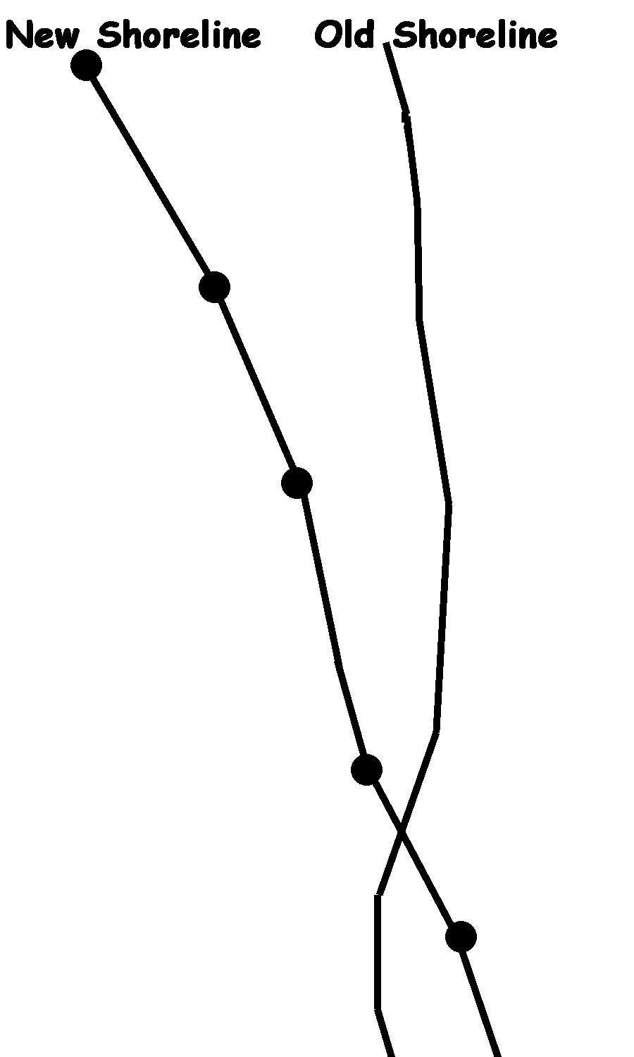
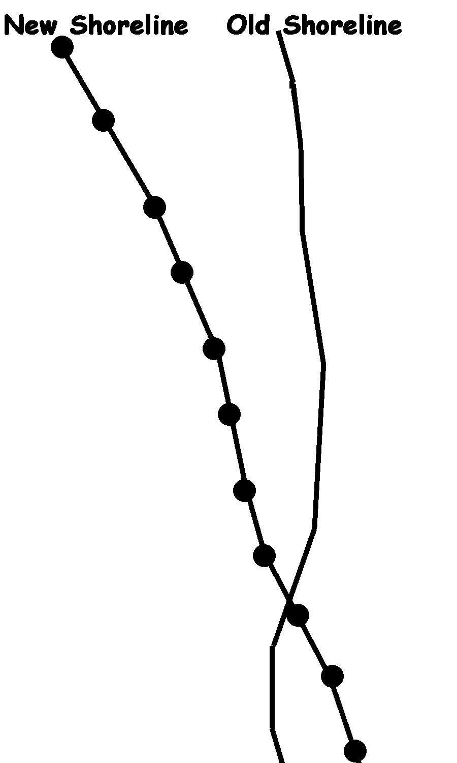
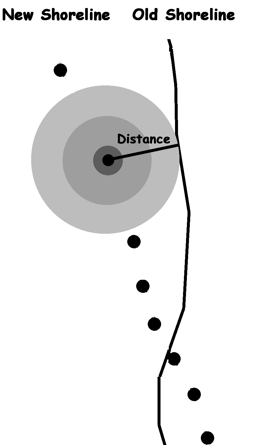
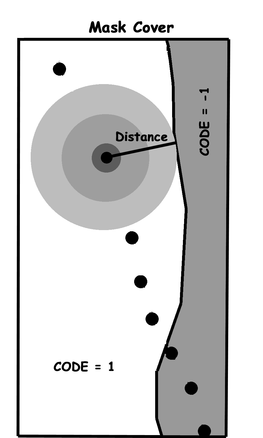
Figure 2. A
conceptual view of the processing steps used to calculate the shoreline change
rates for the Columbia River Littoral Cell: (a) shoreline selection, (b) line
densification, (c) distance calculation, and (d) change rate calculation.
The first step in the calculation of shoreline change rates is the selection of the two shorelines to be analyzed (Figure 2a). In the second step, nodes are added along the new shoreline at a predefined interval, in this case 100-m (Figure 2b). During the third step the new shoreline coverage is converted to a point coverage, where the point locations are identical to the node locations. In the fourth step the distance between each point (on the new shoreline) to the nearest line segment in the old shoreline is calculated (Figure 2c). Lastly, the distances calculated in step four are divided by time (time in decimal years between the two shorelines) and multiplied by the variable CODE in the mask cover (Figure 2d). The mask cover is used to identify eroding vs. accreting areas within the region of interest.
Table 2. Bulk shoreline change rates for each sub-cell within the Columbia River Littoral Cell. Values shown are in meters per year (negative values indicate erosion).
Sub-cell Minimum Mean Maximum Time Period
North
Beach -10.94 4.46 46.53 187x
to 1926
-5.33 7.83 17.58 1926
to 195x
-6.33 1.59 7.73 195x
to 1974
-19.96 0.06 6.51 1974
to 1987
-6.38 2.96 13.28 1987
to 1995
-10.38 11.64 25.40 1995
to 1999
Grayland
Plains -7.77 5.33 8.60 187x
to 1926
-40.67 -2.60 7.39 1926
to 195x
-30.24 -2.91 4.07 195x
to 1974
-23.74 -0.14 11.40 1974
to 1987
-36.00 0.63 13.75 1987
to 1995
-31.99 -1.56 76.15 1995
to 1999
Long
Beach -3.16 2.46 40.48 187x
to 1926
-14.17 2.34 21.78 1926
to 195x
-12.72 3.12 16.64 195x
to 1974
-6.67 3.72 48.27 1974
to 1986
-18.83 5.13 28.32 1986
to 1995
-19.02 0.29 33.12 1995
to 1999
Clatsop
Plains -1.31 9.51 74.42 187x
to 1926
-13.15 5.24 17.81 1926
to 1942
-18.12 0.82 18.69 1942
to 1986
-33.10 2.23 12.14 1986
to 1995
-16.70 -3.75 28.05 1995
to 1999
RESULTS
The
CRLC has had a long-term accretion trend throughout its 164-km length since
4,000 years BP (Woxell 1998). To describe how the shoreline has changed through
historic times (1870 to present) change rates were calculated for each 100-m
section of the coast and 141 transects taken at one kilometer intervals
(Daniels et al. In press). The bulk
statistics for each sub-cell (see Figure 1) in the region are shown in Table 2.
Note that the 1995 to 1999 rates cover the most recent El Niño event and may
reflect a non-equilibrium state for the region.
CONCLUSION
Modification of the change rate AML used by the Southwest Washington Coastal Erosion Study to use vector vs. raster processing methods resulted in a ten fold increase in the number of shorelines that may be analyzed in a given day. Prior to the development of this vector approach, the raster based change rate program was run for each unique set of shorelines (i.e., where each shoreline segment with a different collection time was considered unique). The vector version of the program is able to retain the mapping date (as a decimal year) of each individual shoreline throughout the entire analysis. Thus, composite shorelines may now be used as input into our change rate program.
REFERENCES
Daniels, R.C., D. McCandless, and R.H. Huxford. In press. Historical shoreline change rates for the Columbia River Littoral Cell. In Southwest Washington Coastal Erosion Workshop Report 2000, Gelfenbaum, G. and G.M. Kaminsky (eds.). U.S. Department of the Interior, U.S. Geological Survey, Menlo Park, CA.
Daniels,
R.C. and R. H. Huxford. 1998. Coastline mapping and identification of erosion hazard areas in Pacific County, Washington. In 1998 ESRI International User
Confererence Proceedings. ESRI, Redlands, CA.
Gelfenbaum,
G. and G.M. Kaminsky. 2000. Southwest Washington Coastal Erosion Workshop
Report 1999. Open-file Report 00-439. U.S. Department of the Interior, U.S.
Geological Survey, Menlo Park, CA.
Woxell,
L.K. 1998. Prehistoric Beach Accretion Rates and Long-Term Response to
sediment Depletion in the Columbia River Littoral System, USA. Master’s
Thesis, Portland State University, Portland, OR, 206 p.
ACKNOWLEDGMENTS
The
research described in this paper was funded jointly by the State of Washington,
Department of Ecology, and the U.S. Geological Survey, Coastal and Marine
Geology Program, in support of the Southwest Washington Coastal Erosion Study.
For more information on the study please visit our web site at
http://www.ecy.wa.gov/programs/sea/swce.